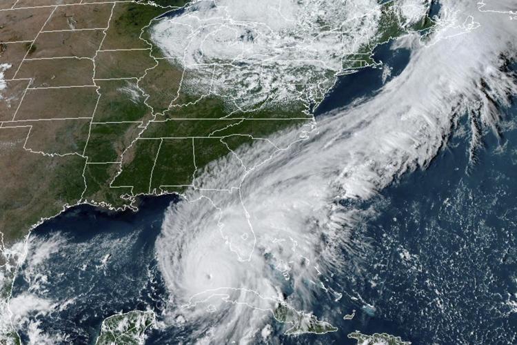

As Earth gets warmer, scientific predictions are getting more accurate by the day. With climate change raging across the world, extreme weather events are being fueled with new energy and the same is happening with Hurricane Ian, which is battering Cuba while on its way to Florida.
The Category-3 storm not only gained wind speed but also strength within a day as seen in several other Atlantic storms in the recent past. The hurricane is expected to become a Category-4 storm as it moved ahead towards the coast of Florida through the Gulf of Mexico.
But why is it getting so ferocious and that too so quickly? The answer to that question is global warming.
Why is Hurricane Ian getting dangerous?
The hurricane is being turbocharged by warm waters that it has found in the Caribbean. The storm became 67 per cent stronger in less than 22 hours from Monday to Tuesday and is bearing down as a likely Category 4 hurricane that threatens to deliver hellish storm surges.
The hurricane came across warm water in the Caribbean, which is about 1 degree warmer than normal seawater. This temperature rise in the Caribbean is attributed to climate change, which acts like a fuel triggering the storm. Meanwhile, the accumulation of heat-trapping gases from emissions and fossil fuels adds to the wound as it makes storms slower and wetter.
The greenhouse gases are responsible for triggering deadly storm surges through sea-level rise, worsening freshwater flooding, and increasing the proportion of monster Category 4 and 5 storms. According to experts, the current hurricane season had been uncharacteristically mild until about a week ago because of dry air in the Atlantic
More powerful hurricanes hold more moisture, which makes them more explosive in the form of torrential rains and storm surges, experts say.
Analysis of data from the National Hurricane Center reveals that while hurricane seasons fluctuate year-to-year when looked at over 10-year intervals, there are roughly 25 per cent more rapidly intensifying storms in the Atlantic and Eastern Pacific now than 40 years ago, the Associated Press reported.
Meanwhile, a yet-to-be peer-reviewed study reveals that hurricanes near the coast — a dangerous point for people — storms are intensifying more quickly than ever before. “It’s more likely because of climate change,” Karthik Balaguru, a Pacific Northwest National Lab climate scientist told AP.
What’s next for Hurricane Ian?
The Hurricane is expected to get even stronger as it comes across the warm Gulf of Mexico, with wind speeds expected to hit over 210 kilometers per hour. Ian hit a Cuba that has been struggling with an economic crisis and has faced frequent power outages in recent months.
It made landfall as a Category 3 storm on the island’s western end, devastating Pinar del Río province, where much of the tobacco used for Cuba’s iconic cigars is grown.